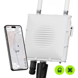


Dronetag Scout Aviation is a fixed receiver that puts drones and manned aircraft on the same map. It identifies drones broadcasting Remote ID, shows where their operators are standing and keeps every flight on record, while a dual-band aviation antenna adds ADS-B, FLARM, ADS-L, OGN and UAT traffic. All without transmitting anything, and at a fraction of what traditional detection technologies cost.
Every Remote ID antenna receives on both 2.4 GHz and 5 GHz, reaching up to 10 km (6 mi) in Aviation Baseline and 25 km (15 mi) in Aviation High Performance. Scout can be deployed within minutes and detections flow straight into the Dronetag App or into any third-party system over our API, TAK and SAPIENT. Multiple Scouts interconnect to extend coverage across a single site, a city, or a national network.
Only need drones? See Scout Remote ID.
Recommended add-ons for your Scout
Complete your setup with the right connectivity and software. Start with the Cloud Licence - it connects your Scout to the Dronetag App.
Required for the Dronetag App
|
Required Scout Cloud Licence
Needed to use your Scout with the Dronetag App. Without it, you won't get live detections, history, alerts or data export in the app.
|
Add licence |
Connectivity
|
Scout LTE Data Plan - Aviation
Cellular data for Aviation configurations, carrying both drone and manned aircraft detections.
|
Details |
 Manuals & guides available
We strongly recommend exploring our comprehensive website at Help.dronetag.com.
 Check product availability
Some of our items are currently on backorder, check the availability before you order.
 Be aware of cancellation fees
Orders are subject to cancellation fees, as outlined in our Terms & Conditions.
 App
 Compatibility
 Remote ID
 Power
 Dimensions
 Weight
Dronetag Scout Aviation puts drones and manned aircraft on the same map. It identifies drones broadcasting Remote ID, shows where their operators are standing and keeps every flight on record, while a dual-band aviation antenna adds ADS-B, FLARM, ADS-L, OGN and UAT traffic. All without transmitting anything and at a fraction of what traditional detection technologies cost.
Configurations
Scout Aviation ships in two configurations. Both include LTE as standard and both are available in a global and a US version.
Aviation Baseline
Two dual-band omnidirectional antennas for full 360° Remote ID coverage up to 10 km (6 mi), plus a dual-band aviation antenna covering ADS-B, FLARM, ADS-L, OGN and UAT, so manned traffic appears on the same map as the drones.
Aviation High Performance
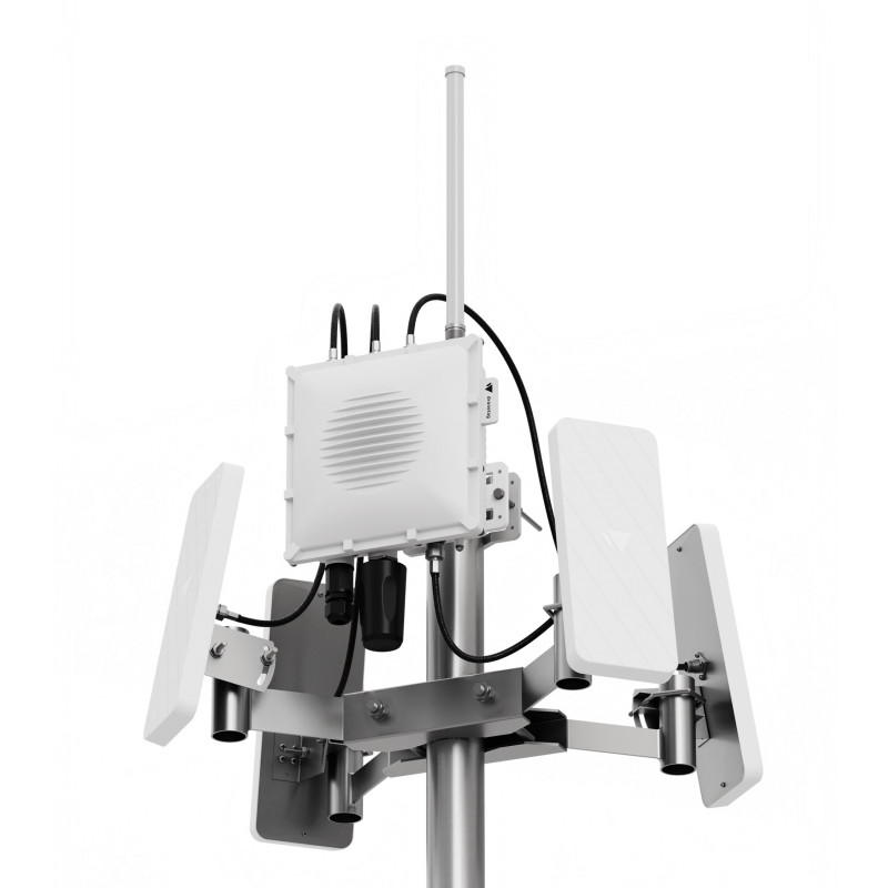
Four dual-band sector antennas plus the dual-band aviation antenna. Long-range Remote ID at up to 25 km (15 mi) and manned traffic from a single mast.
Only need drones? Scout Remote ID comes in Baseline and High Performance, without the aviation antenna. See Scout Remote ID →
Choosing a configuration
How far do you need to see?
Aviation Baseline covers Remote ID up to 10 km (6 mi). Aviation High Performance reaches 25 km (15 mi) on its sector antennas, which give more reliable long-range reception where 2.4 and 5 GHz interference is heavy, such as urban areas and airports.
Where are you deploying?
The US version is FirstNet capable (FirstNet firmware arriving in an upcoming update). Everywhere else, choose Global.
Need something outside these configurations, such as a build without LTE or a reduced sector count? Contact sales@dronetag.com. Custom configurations are quoted per project and carry an extended lead time.
What Scout Aviation gives you
Drones and Manned Traffic, One Map
A single dual-band aviation antenna covers ADS-B, FLARM, ADS-L, OGN and UAT alongside Remote ID. Because the sector antennas carry both Remote ID bands themselves, the aviation antenna no longer competes with drone coverage – long-range Remote ID and manned traffic come from the same mast.
Both Bands, at Superb Range
Every Remote ID antenna receives across 2.4 GHz and 5 GHz, omnidirectional and sector alike. Most receivers cover 5 GHz on an omnidirectional antenna only, which holds that coverage close to the mast. Scout carries both bands out to range on four sector antennas, and is the only receiver on the market that tracks a Skydio at 8 km (5 mi).
The Pilot, on a Map
Remote ID carries the operator position alongside the aircraft. Open it in Google Maps with one click and send someone to the spot while the flight is still in the air. Every detection is logged with its track, ready to hand to law enforcement.
Your Airspace, Your Rules
Whitelist your own operations and your known contractors so the map shows you what is left. Draw geofence zones around what you protect and get instant alerts the moment something enters them. Historical flights stay available for review and export, in the Dronetag App and through Dronetag Skyprint.
Deployed in Minutes, Built to Last
Pole, wall, tripod or the roof of a van, with a single PoE connector carrying both power and data and LTE included as standard. An IP67-rated aluminum enclosure with built-in heating and passive cooling holds performance from -20 to 50 °C (-4 to 122 °F). Optional lightning protection is available. As a passive receiver, Scout transmits nothing and interferes with nothing already installed.
Built to Integrate
The hardware, firmware and software are developed entirely in-house, and the receiver is TAK and SAPIENT compatible, so it drops into an existing UTM, C-UAS or third-party system over our API.
What changed from Gen 1
Gen 2 rebuilds the RF frontend so that every antenna carries both bands, not just the omnidirectional one. That single change is what puts 5 GHz reception out at range, and it frees the antenna position that previously had to carry it – which is what makes room for aviation alongside long-range sectors.
| What changed | Scout Gen 1 | Scout Gen 2 |
|---|---|---|
| Aviation coverage | Separate ADS-B variant, two antennas | One dual-band antenna covering ADS-B, FLARM, ADS-L, OGN and UAT |
| Sectors plus aviation | Not possible | Aviation High Performance |
| Dual-band reception | Omnidirectional antenna only | Every antenna, omnidirectional and sector |
| Sector antennas | 2.4 GHz only | Dual-band, 2.4 GHz and 5 GHz |
| Skydio detection range | About 1.6 km (1 mi) | 8 km (5 mi) on the sector antennas |
| LTE | Optional upgrade | Included as standard |
| Public safety networks | Not supported | The US version is FirstNet capable (FirstNet firmware arriving in an upcoming update). |
Already running Gen 1? The enclosure and mounting are unchanged, so existing poles, brackets and PoE runs carry over and only the antennas differ. Contact sales@dronetag.com to talk through upgrading a site.

Antenna Options
The dual-band aviation antenna covers ADS-B, FLARM, ADS-L, OGN and UAT alongside Remote ID on a single element. Because the sector antennas now carry both Remote ID bands themselves, the aviation antenna no longer competes with Remote ID coverage, which is what makes Aviation High Performance possible.
For Remote ID, Scout receives on both 2.4 GHz and 5 GHz across every antenna. Omnidirectional antennas give full 360° coverage and suit sites where flights can approach from any direction. Sector antennas have a 90° beamwidth and give more reliable long-range reception in complex environments such as urban areas and airports, where electromagnetic interference is significant.
Antenna Mounting
Aviation Baseline mounts directly and needs no additional hardware. Aviation High Performance includes the Multi-Antenna Pole Adapter (4x) at no extra cost.
Operating Modes
Scout supports four configurable operating modes, allowing seamless integration into various workflows and infrastructure types.
01 Sensor Mode
Scout works as a standalone Remote ID receiver and outputs raw detection data to your own infrastructure. Ideal for users who don’t need cloud services and prefer to process, store or visualize the data in their own systems. Based on the serial number, Scout can identify the drone manufacturer. No access to Dronetag Cloud is included.
02 Sensor+ Mode
As Sensor Mode, with data still processed in your own infrastructure, but Scout enriches the raw output and identifies the specific drone model as well as the manufacturer. For users who want to stay self-hosted and still benefit from Dronetag’s data interpretation, device management and support.
03 Cloud Mode
Connects directly to the Dronetag Cloud platform. Detections are sent automatically and visualized in real time in the Dronetag web or mobile app. For users who need remote access and cloud workflows without building their own backend.
04 On-Premise Mode
For environments where data cannot leave the local network. Scout sends Remote ID data to a local server, accessed by a computer running Dronetag software. All processing and visualization happens locally, without any connection to the cloud.
Find more details in the document available for download here.
Connectivity and licensing
LTE is included in both configurations, so no separate modem upgrade is needed. Scout also supports PoE+ 802.3at and is PoE 802.3af compatible.
Please note: A SIM card is not included by default and must be provided by the user. If you would like to use a SIM card provided by Dronetag, add a Scout LTE Data Plan - Aviation, which carries both drone and manned aircraft detections.
Please note: To use Scout with the Dronetag App you also need a Scout Cloud Licence. Without it, Scout still runs in Sensor or Sensor+ mode and outputs to your own infrastructure, but live detections, history, alerts and export in the app are not available.


What Scout Aviation Detects
Remote ID is the digital licence plate most commercial drones broadcast continuously in flight. Scout receives those broadcasts wherever Remote ID regulation is in place, on Bluetooth 4 and 5, Wi-Fi Beacon and Wi-Fi NaN, across 2.4 and 5 GHz. Which aircraft broadcast, and which do not, is set by the standard rather than the receiver. For a comprehensive list of drones, please visit this website.
The dual-band aviation antenna adds manned traffic broadcasting ADS-B, FLARM, ADS-L, OGN or UAT, so it appears on the same map as the drones.
Who Is It For
Scout is used by 350+ public safety agencies, critical infrastructure operators and armed forces worldwide, from fixed sites like airports, prisons, power plants and stadiums, to agencies running Drone as First Responder programs where flights need to be followed across the whole response area rather than seen near the launch point.
See Scout working, in the field
Dronetag Skyprint is the analytics layer over our Remote ID receiver network. It turns raw detections into flight counts, drone counts and airspace reporting you can hand to a regulator, a chief or a board.
Operators publish their own installations to the Skyprint showcase, each one listing the flights seen, the drones detected and the maximum range that receiver has actually achieved. It is the quickest way to judge what Scout will do at your site: airports, city-wide deployments, public safety training centres and university campuses, across very different terrain and interference conditions.
Real installations, real numbers, published by the people running them.

Applications
Scout is deployed wherever a fixed site needs to know what is flying over it.
Airports & Critical Infrastructure
Public Safety Agencies
Police Departments
Fire Departments
Search & Rescue Teams
Prisons & Correctional Facilities
Power Plants & Energy Facilities
Stadiums & Venues
Event Security & Political Events
Environmental & Wildlife Protection
Urban Planning & Local Government
Private & Corporate Security Teams


You might also like
Dronetag Scout Aviation is a fixed receiver that puts drones and manned aircraft on the same map. It identifies drones broadcasting Remote ID, shows where their operators are standing and keeps every flight on record, while a dual-band aviation antenna adds ADS-B, FLARM, ADS-L, OGN and UAT traffic. All without transmitting anything, and at a fraction of what traditional detection technologies cost.
Every Remote ID antenna receives on both 2.4 GHz and 5 GHz, reaching up to 10 km (6 mi) in Aviation Baseline and 25 km (15 mi) in Aviation High Performance. Scout can be deployed within minutes and detections flow straight into the Dronetag App or into any third-party system over our API, TAK and SAPIENT. Multiple Scouts interconnect to extend coverage across a single site, a city, or a national network.
Only need drones? See Scout Remote ID.
Recommended add-ons for your Scout
Complete your setup with the right connectivity and software. Start with the Cloud Licence - it connects your Scout to the Dronetag App.
Required for the Dronetag App
|
Required Scout Cloud Licence
Needed to use your Scout with the Dronetag App. Without it, you won't get live detections, history, alerts or data export in the app.
|
Add licence |
Connectivity
|
Scout LTE Data Plan - Aviation
Cellular data for Aviation configurations, carrying both drone and manned aircraft detections.
|
Details |